
News
City of Charleston’s Hurricane Ian Update: September 29th AM
The city of Charleston remains in OPCON 2 as officials prepare for impacts from Tropical Storm Ian.
Emergency declaration/ordinances: On Thursday morning, in anticipation of Tropical Storm Ian, Charleston Mayor John Tecklenburg declared a state of emergency in the city of Charleston, and City Council passed the following three emergency ordinances:
- An ordinance authorizing Police Chief Luther Reynolds or his designees to limit vehicular traffic on certain streets as necessary to protect public safety;
- An ordinance authorizing Mayor John Tecklenburg, in consultation with Police Chief Luther Reynolds, to limit vehicular traffic in designated areas as necessary to protect public safety; and
- An ordinance authorizing Mayor John Tecklenburg, in consultation with Police Chief Luther Reynolds, to impose a curfew if and only if necessary to protect public safety.
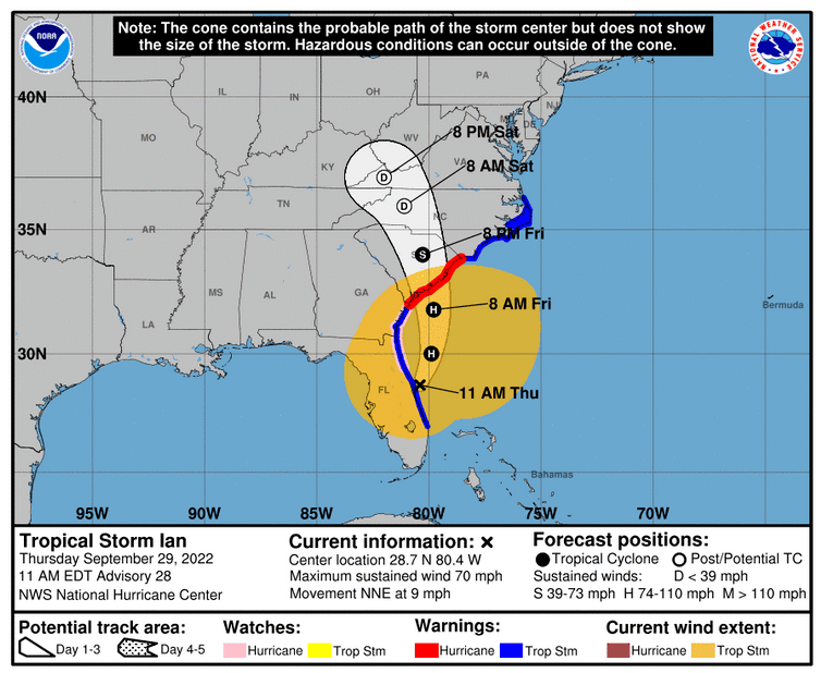
Currently projected impacts: The National Weather Service has issued a Hurricane Warning, a Tropical Storm Warning and a Storm Surge Warning for Charleston County, anticipating a three- to five-foot storm surge in the next 24-hour period.
Tropical Storm Ian is projected to make landfall near the South Carolina/ Georgia border on Friday with 70 mph sustained winds, according to the National Weather Service.
Thursday: Major coastal flooding is expected alongside the 11 a.m. high tide. Light rain is possible in the afternoon. By late Thursday, considerable flooding is expected from heavy rainfall and the 11:05 p.m. high tide. Winds are expected to pick up throughout the day.
Friday: About four- to eight-inches of rain is projected with up to a foot of rainfall possible. Considerable flooding is expected with life-threatening storm surge of three- to five-feet, especially around the high tides at 11:44 a.m. and 11:55 p.m. Sustained tropical force winds (70-75 mph) are expected early. The strongest winds are likely late morning to around midnight. Isolated tornadoes are possible.
At this time, the primary threat to the city of Charleston is expected to be flooding due to heavy rainfall and high tides. Most rainfall will occur on Friday.
24-hour citizen information line: The 24-hour citizen information line is now activated. Call 843-724-7311 with any questions or to report damage.
Parking garages: The city of Charleston will open the following garages to City residents, free of charge, beginning at 5 p.m. Thursday, September 29 to 5 p.m. Saturday, October 1:
- Aquarium Garage – 24 Calhoun Street
- East Bay/ Prioleau – 25 Prioleau Street
- Queen Street – 93 Queen Street
- Visitor Center – 63 Mary Street
- 99 West Edge – 99 West Edge Street
All cars must be removed from the garages by 5 p.m., Saturday, October 1. Anyone who
uses the garages must follow the following process:
- Vehicles need to be removed by designated time to be eligible for free parking.
- Pull a ticket upon entering
- When leaving – Press the black “assistance” button on the upper right-hand side of the call box. An attendant will respond to assist you.
- State you were parking to avoid the flooding.
- Provide your name and address when requested.
- Insert your ticket into the machine (if you have not already done so)
- Attendant will raise the gate for you to exit
No boats, trailers or golf carts are allowed.
Garbage and trash collection: Thursday’s residential garbage and trash pickup is currently on schedule, with crews reporting on Thursday to ensure all garbage and trash is picked up completed before the storm. With landfills closing at 2 p.m. on Thursday, there is a chance that some garbage and trash may not be picked up. If garbage and trash is not picked up by 4 p.m. on Thursday, residents are asked to bring their garbage bins and trash away from the road until the storm subsides.
Commercial garbage collection on Friday will not be collected. With no residential garbage and trash pickup normally scheduled Friday, residents are asked to secure garbage bins and trash in anticipation of the storm.
Shelters: Charleston County is opening two shelters.
- Pet Shelter – 3841 Leeds Avenue, North Charleston, opens at 8 a.m. on Thursday, September 29.
- Dunston Elementary – 1825 Remount Road, North Charleston, opens at 12 p.m. on Thursday, September 29.
City office closures: City of Charleston offices, including the Municipal Court, will be closed beginning at 3 p.m. Thursday and all day Friday. Charleston Gaillard Center staff will be released early on Thursday and will be off Friday and Saturday, with some working from home.
Recreation: All Recreation programs and activities will be cancelled beginning Thursday at 3 p.m. and remain cancelled through Saturday.
Sandbag distribution: As of Wednesday night, roughly 15,000 sandbags were assembled and picked up at the five designated locations around the city.
Distribution will continue until 3 p.m. Thursday, weather permitting. There is a limited number of free sand and bags available for residents to build their own sandbags. Residents should bring their own shovels for assembly. Staff will be on-site to assist, as needed.
The self-serve pick-up locations are:
- Bee’s Landing Recreation Center, 1580 Ashley Garden Boulevard (West Ashley)
- Hampton Park parking lot on the corner of Ashley Avenue and Mary Murray Drive (peninsula)
- Seven Farms Drive behind Governor’s Park Dog Park, Under I-526 (Daniel Island)
- Grace Bridge Street parking lot between America and East Bay streets (peninsula)
Sandbag locations with town of James Island:
- James Island Town Hall, 1122 Dills Bluff Road (James Island)
There is a limit of 10 sandbags per residence. To purchase additional sandbags, citizens should contact a local home hardware store.
Charleston Police Department Update: Police Department command staff members continue to staff the Municipal Emergency Operations Center. Preparations are on-going with life safety as the department’s top priority. As of Thursday morning, the Police Department has implemented an alternate staffing schedule to ensure the maximum amount of personnel are on duty throughout the duration of the storm.
Storm surge and high tides are a major concern. Due to flooding concerns, officers are prepositioning barricades in all low-lying areas and roads will be closed as water rises. Motorists are warned to not drive around barricades and exercise great caution as they travel during the next three days. The Police Department urges citizens to prepare for the storm with all basic required necessities to include food, water and medications.
Charleston Fire Department Update: The Fire Department is reaching out to high-risk populations to remind them of available resources. Additional team members and units will be placed in service to assist with the potential impact of the storm.
In addition to preparing for the storm, the Fire Department we will be staffing two high water vehicles to assist with water rescues and two utility vehicles to clear small trees and debris in order to assist with response. Additionally, inflatable boats have been prepared in case the need arises.
Members of the Fire Marshal Division have worked to contact various job sites to reduce hazards and have reached out to some of our residents in vulnerable areas. The Fire Department asks builders to fill out a Job Site Pre-Storm Assessment: https://www.charleston-sc.gov/FormCenter/Fire-Department-12/Job-Site-PreStorm-Assessment-52. Additional information for businesses to prepare for impending storms is available here: https://charleston-sc.gov/DocumentCenter/View/32625/Hurricane_Prep_For_Business_Community_Ver_2018-09-10.
Charleston Department of Livability and Tourism: Livability officers will be patrolling their assigned areas identifying and removing potential obstructions from storm drains and removing garbage cans from the streets Thursday and Friday. Carriage tour operations will be suspended at 1:30 p.m., Thursday and all day Friday. Carriage operations will tentatively reopen on Saturday at 9:00 a.m.
More information: Due to the potential for flooding, the city’s Stormwater Department has reserved temporary pumps to position in low lying areas. Stormwater and Public Service Department crews continue to clean ditches and drains in flood-prone areas. Citizens can visit the city’s Adopt-a-drain webpage (https://www.charleston-sc.gov/1984/Adopt-A-Drain) for information on ways they can help.
Monitor the next several day’s tide forecast in real time with the city-developed TIDEeye app. TIDEeye reports tide and weather data from multiple sources in real-time to aid in decision making. Data sources include the National Weather Service, NOAA, City-operated weather stations, Waze user reports, and City reported road closures: https://gis.charleston-sc.gov/tideeye/.
Additionally, road closures updated in real-time are available here: https://gis.charleston-sc.gov/road-closures-regional/.
Citizens are encouraged to begin making preparations now. The city’s Hurricane Information webpage can be accessed at https://www.charleston-sc.gov/974/Hurricane-Information. Updates on Hurricane Ian will be released and posted to the webpage as new information becomes available.
For the most accurate and up-to-date weather forecasts, residents should stay tuned to the National Hurricane Center and National Weather Service Charleston websites, as well as local media and the FEMA app. Additional hurricane preparedness information can be found at www.scemd.org.


Miracle Holiday Pop-Up Bar Returns to Handcraft Kitchen & Cocktails This Month

Big Brothers Big Sisters hosts BIG Lowcountry Boil

Comedy Legend Katt Williams Returns to the North Charleston Coliseum in March

Parade, Vendor Applications Open for Upcoming ‘Holiday Magic’ Events

“Know Whatcha’ Know” Release Party & Fashion Show Set for Saturday
