
News
Black River Park Comes to Life with New Community-Driven Master Plan
A multi-year collaborative effort aimed at reconnecting residents of Williamsburg and Georgetown Counties to the State Scenic Black River and boosting local tourism efforts is a step closer to reality with the release of a community-driven Black River Water Trail & Park Network Master Plan.
Individuals representing community, government, and non-profit leaders provided input to the plan which offers a detailed strategy to meet the open space and access needs of communities along the water, create nature-based tourism opportunities to boost the local economy, and provide critical flood mitigation for riverside communities.
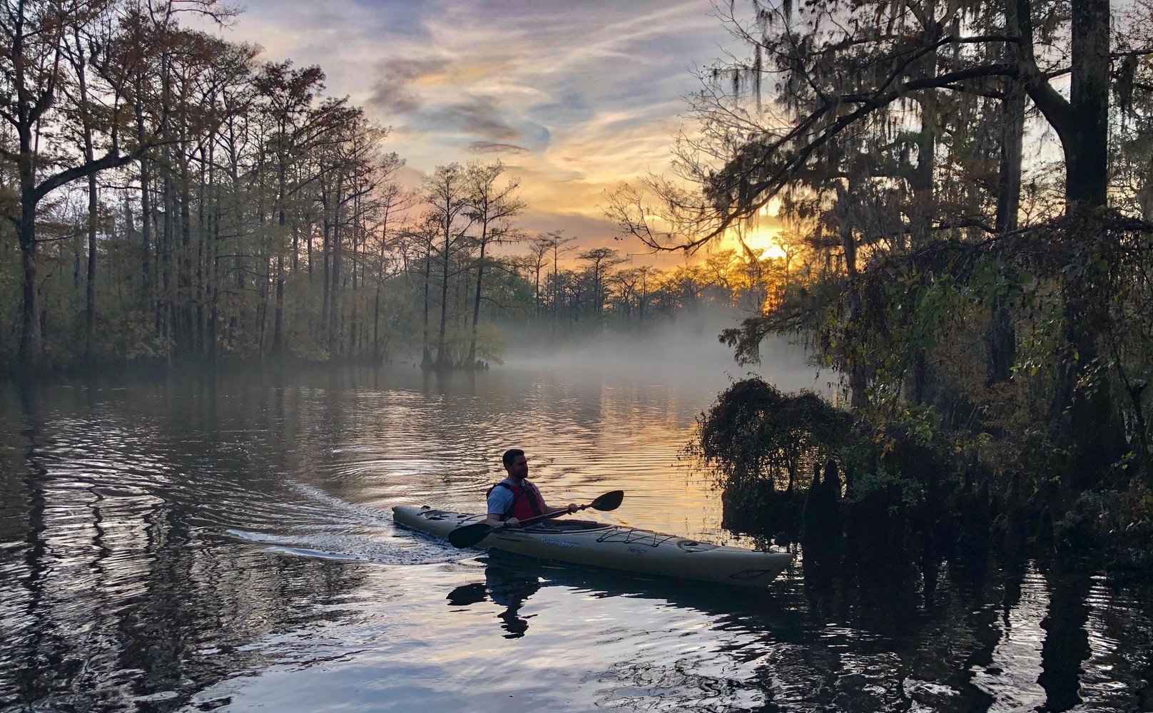
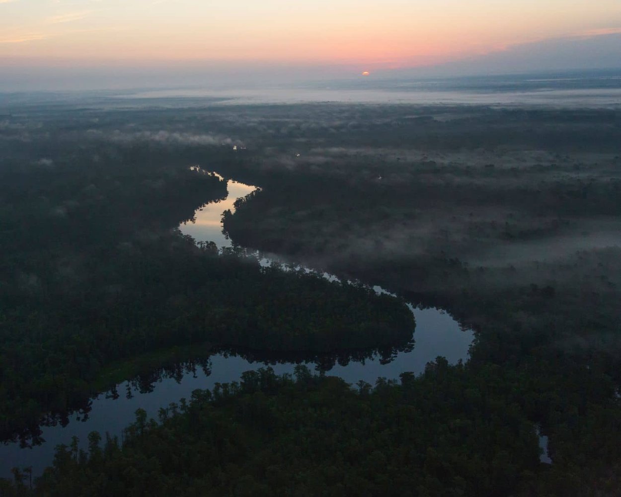
The plan is designed around the new Black River Initiative, a 70-mile-long riverine network of 12 local, state, and private parks connected by a recreational water trail along the river between the towns of Kingstree and Georgetown. The new park network includes South Carolina’s first new state park in nearly 20 years, the state’s first-ever riverine park, and the first state park in this majority Black region of the state.
“Historically the Black River was a center-point of livelihoods, commerce, and travel connecting people and places. But in the last century we turned away from the river,” remarks Dr. Maria Whitehead, vice president, Land in the Southeast, Open Space Institute, one of the leading architects of the overall development of the new park network. “The Black River Water Trail & Park Network Master Plan seeks to change that. The master plan taps this stunning and ecologically vital river’s potential by creating a world-class park network that will also provide recreation, tourism, and flood resilience.”
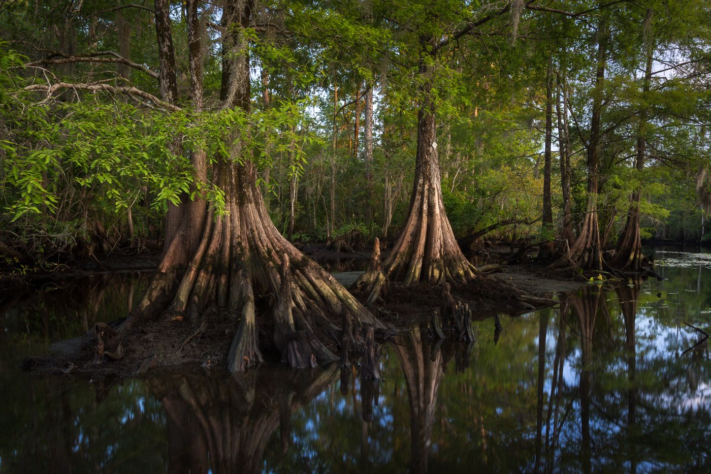
Totaling approximately 9,000 acres, the park network will wind through two counties, extending 70 miles from the town of Kingstree, almost to the confluence of the Black River with the Pee Dee River, just north of Georgetown. It is surrounded by another 16,000 acres of private land protected by conservation easements.
“The people of Georgetown and Williamsburg Counties know the Black River best,” comments Beth Goodale, director, Georgetown County Recreation and Community Services. “We are both excited about and invested in the park plan not only because we helped develop it but also because it’s a plan for prosperity. Shop owners, restaurants, and other businesses will benefit from visitors who come to share in our special place.” In an incredible statement of regional support for the project, Williamsburg and Georgetown Counties and two riverfront towns, Kingstree and Andrews, recently passed resolutions in support of the Black River Water Trail & Park Network.
The release of the master plan coincides with the announcement that the Open Space Institute has secured two additional riverfront properties which have or will soon be donated to SCPRT, totaling more than 2,000 acres that will be included in the project. The Open Space Institute acquired and donated the network’s first state parcel to the South Carolina Department of Parks, Recreation & Tourism (SCPRT) in April 2021.
Additionally, The Nature Conservancy will transfer another riverfront property to the project. The Sims Reach property consists of 143 acres that sit along Sims Reach Road and provide access to both sides of the Black River. It secures one mile of river frontage and will provide a critical access point for parking and paddling midway through the river.
“Our goal for this new state park is to give the people of Williamsburg, Georgetown and surrounding counties the most and best access possible to their beautiful stretch of the Black River,” says Dale Threatt-Taylor, executive director, The Nature Conservancy in South Carolina. “Black River conservation partners are putting together the puzzle pieces of a park that all South Carolinians will be proud of, that will drive eco-tourism dollars and that will help protect this area from floods.”
Other parks in the Black River Water Trail & Park Network include Town of Kingstree’s Black River Landing; the privately owned, publicly available Black River Cypress Preserve; The Nature Conservancy’s Black River Preserve; and Georgetown County’s Rocky Point Community Forest.
With the park land secured last spring, local partners commenced a year-long community outreach and planning process. The effort was aimed at incorporating local input to better understand what residents, businesses, and area officials want in their parks; to guide decision-making; and to fully maximize the recreational, economic, and environmental benefits the park network can provide. The process generated public comments from nearly 1,500 people that helped to shape the master plan which serves as a blueprint for connecting the people and communities in the region with the river for public enjoyment, while deepening a range of economic opportunities.
The newly completed master plan calls for the creation of amenities including camping options, picnic shelters for group events, hiking trails and boardwalks, restrooms, and a visitor center. It includes improved access to the river for fishing and swimming, and a water trail for paddlers to explore the beauty of the river from one point to another. Unique experiences such as paddle-up platform campsites and flood-resilient treehouse accommodations are also included.
While the Black River may feel remote and wild to those who spend time on the water, this park network is within 100 miles of 40 percent of the state’s population and an easy hour drive from tourist-meccas such as Charleston and Myrtle Beach.
“We’ve seen a remarkable increase in demand for parks and public recreation opportunities,” said Paul McCormack, director, South Carolina State Park Service. “For its public access component alone, the Black River Water Trail & Park Network and its plan are coming at an ideal time. This park is going to improve the health and wellbeing of the region’s residents and visitors for generations to come. We are honored to be trusted with this remarkable resource.”
“As designed, a visitor can spend a few hours picnicking or hiking at one of the sites,” states Gates Roll, owner of Black Water Outside, a local guide service. “Or, for the more adventurous, put a kayak in at Kingstree and spend a week paddling down to Rocky Point stopping and camping at the many park sites along the way. There is simply nothing like it in South Carolina, and I can’t wait.”
Expanding Economic Opportunities
The park network is expected to serve as a springboard for economic progress in one of the most economically challenged and overlooked areas of the state. From the build-out of the state park system to recreational tourism, the project offers a range of economic opportunities in one of the most economically challenged areas of the state.
After working for 30 years with small, rural towns all over the country, Greenville-based regional planning expert Tripp Muldrow is optimistic that the Black River project will create enormous economic opportunities for the residents and businesses of Georgetown and Williamsburg counties, and beyond.
“In a state where most of the financial benefits of tourism flow to coastal resort towns, the prospect of this recreational network could be a complete economic gamechanger by bringing a spotlight and funding to these small, rural, inland communities,” said Muldrow, a fellow of the American Institute for Certified Planners.
Some have already seen an uptick in visitors. “The Black River is becoming more and more popular,” notes Crystal Morris, Tasteful Creations Catering in Andrews who prepares boxed lunches for paddlers. “In just a year my small local business has expanded three-fold. Everybody who visits the river asks the same three questions – ‘Where can we eat, where can we stay, and when can we come back?’”
Reducing Local Flooding Threats
In addition to the terrific recreational and economic potential the new network holds, leaders heralded the project for its important flood-prevention benefits since undeveloped riverfront land is an important tool in reducing the costly and deadly impacts associated with increasingly stronger and more frequent storms.
“Undeveloped mature floodplains act as natural sponges of floodwaters, absorbing and slowing the movement of water,” said Ben Duncan, chief resilience officer, South Carolina Office of Resilience. “When conserved on a landscape scale, the park properties, along with other protected lands, will provide a natural buffer against catastrophic flooding for nearby communities and prevent additional construction of homes within the floodplain. By protecting the land along the river, we have the tremendous opportunity to save area residents and businesses from the devastation that results from extreme flooding events that are becoming more and more frequent.”
Additionally, permanently protected, water-storing floodplains save money by reducing flood insurance costs through the FEMA’s Community Rating System program, avoiding costs for emergency services to communities and avoiding damage to public and private property.
Cultural Resources
One of the guiding values of the project is to better understand, protect, and interpret the cultural resources along the river. The character of the Black River is defined by its local history and culture, its historic places, and the generational impacts on the region. The recent history of the Black River from Colonial times until present, which includes fascinating Revolutionary and Civil War battles, will be an important component of future park and water trail interpretation.
However, to support the less understood pre-Colonial history, several of South Carolina’s tribes, conservation organizations and university partners collaborating with SCPRT’s staff archeologist through a working group. Together, the partners are focused on identifying and protecting American Indian cultural resources along the river and representing the interest of local tribes in stewarding park properties and contributing to their interpretation.
Funding Details
Based on a phased five-year park build out, SCPRT estimates that the park network infrastructure will cost approximately $45 million. The park network’s advocates are actively pursuing park infrastructure funding. Funding sources include but are not limited to dollars approved by the South Carolina Legislature to support the project through SCPRT’s budget, South Carolina’s Office of Resilience, federal programs within the Departments of Transportation and Housing and Urban Development, the COVID-relief American Rescue Plan Act, and private donors.
“I have never seen such widespread, bipartisan support for a project,” states Tom Mullikin, chairman of the South Carolina Floodwater Commission. “I am confident that working together we will find the funding, build it, and deliver a world class park for the people of South Carolina. In more than four decades working with projects around the world, I have never been associated with a more important and indescribably beautiful project.”
The most recent land acquisitions for the Black River Initiative were completed through the leadership of the Open Space Institute and The Nature Conservancy, with funding from the South Carolina Conservation Bank, North American Conservation Act, National Coastal Wetlands Conservation Grant Program, Knobloch Family Foundation, Butler Conservation Fund via The Nature Conservancy, Conservation Alliance, The Darla Moore Foundation, and other private donors.
Funding for the master plan was provided by the Gaylord & Dorothy Donnelley Foundation, Frances P. Bunnelle Foundation, Judith Haskell Brewer Fund, DSM Nutritional Products, Hilda and Jon Flamholtz, Open Space Institute, The Nature Conservancy, and anonymous donors.
Black River Water Trail and State Park Master Plan Steering Committee
The Master Plan Steering Committee was led by the South Carolina Department of Parks, Recreation & Tourism, the Open Space Institute, The Nature Conservancy, and the Winyah Rivers Alliance in partnership with American Rivers, Black River Cypress Preserve, Black Scenic River Advisory Council, Ducks Unlimited, Georgetown County, National Parks Service, Town of Andrews, Town of Kingstree, Georgetown County, South Carolina Department of Natural Resources, Waccamaw COG, and Williamsburg County.
For more information about the Black River Water Trail, visit http://openspaceinstitute.org/blackriver.


Miracle Holiday Pop-Up Bar Returns to Handcraft Kitchen & Cocktails This Month

Big Brothers Big Sisters hosts BIG Lowcountry Boil

Comedy Legend Katt Williams Returns to the North Charleston Coliseum in March

Parade, Vendor Applications Open for Upcoming ‘Holiday Magic’ Events

“Know Whatcha’ Know” Release Party & Fashion Show Set for Saturday
